Global warming, climate change, all these things are just a dream come true for politicians. I deal with evidence and not with frightening computer models because the seeker after truth does not put his faith in any consensus. The road to the truth is long and hard, but this is the road we must follow. People who describe the unprecedented comfort and ease of modern life as a climate disaster, in my opinion have no idea what a real problem is.
Sea ice extent is the total area of ocean covered by at least 15% sea ice, measured daily via satellite passive microwave sensors (e.g., NSIDC Sea Ice Index). It differs from sea ice area (which accounts for actual ice concentration) or volume/thickness. Extent is a key climate indicator because it reflects seasonal freeze/melt cycles and long-term changes driven by warming.
Seasonal cycle: Arctic sea ice grows in winter (maximum typically in March) and melts in summer (minimum in September).
The Arctic ice extents are now fully reported for 2025, ending the year below average despite a higher rate of growth through December.
Note MASIE 2025 started 1M km2 (or 1 Wadham) below the 19 year average, but cut the deficit to 428k km2, or a gap of 3%. SII v.4 tracked lower than MASIE during December, drawing closer the last week. The chart below shows the distribution of ice extent across the Arctic regions at yearend 2025.
Region
2025365
Day 365 Average
2025-Ave.
2024365
2025-2024
(0) Northern_Hemisphere
12611676
13039302
-427626
12435177
176499
(1) Beaufort_Sea
1071070
1070458
612
1071001
69
(2) Chukchi_Sea
966006
964771
1235
965989
17
(3) East_Siberian_Sea
1087137
1087133
4
1087137
0
(4) Laptev_Sea
897845
897841
4
897845
0
(5) Kara_Sea
867623
887208
-19585
876527
-8904
(6) Barents_Sea
254882
423978
-169096
345715
-90832
(7) Greenland_Sea
668550
595658
72891
574537
94013
(8) Baffin_Bay_Gulf_of_St._Lawrence
768306
982649
-214343
982716
-214409
(9) Canadian_Archipelago
854931
853618
1313
854878
53
(10) Hudson_Bay
1256284
1215695
40589
922416
333868
(11) Central_Arctic
3174354
3206560
-32206
3207164.49
-32811
(12) Bering_Sea
350519
403002
-52483
325489.93
25029
(13) Baltic_Sea
14031
31873
-17843
15271.77
-1241
(14) Sea_of_Okhotsk
366812
393742
-26929
302941
63871
The major deficits are in Barents Sea and Baffin Bay (Atlantic basins), along with smaller losses in Bering and Okhotsk (Pacific basins).
Some years ago reading a thread on global warming at WUWT, I was struck by one person’s comment: “I’m an actuary with limited knowledge of climate metrics, but it seems to me if you want to understand temperature changes, you should analyze the changes, not the temperatures.” That rang bells for me, and I applied that insight in a series of Temperature Trend Analysis studies of surface station temperature records. Those posts are available under this heading. Climate Compilation Part I Temperatures
This post seeks to understand Arctic Sea Ice fluctuations using a similar approach: Focusing on the rates of extent changes rather than the usual study of the ice extents themselves. Fortunately, Sea Ice Index (SII) from NOAA provides a suitable dataset for this project. As many know, SII relies on satellite passive microwave sensors to produce charts of Arctic Ice extents with complete coverages going back to 1989. Version 3 was more closely aligned than Version 4 with MASIE, the modern form of Naval ice charting in support of Arctic navigation. The SII User Guide is here.
There are statistical analyses available, and the one of interest (table below) is called Sea Ice Index Rates of Change (here). As indicated by the title, this spreadsheet consists not of monthly extents, but changes of extents from the previous month. Specifically, a monthly value is calculated by subtracting the average of the last five days of the previous month from this month’s average of final five days. So the value presents the amount of ice gained or lost during the present month.
These monthly rates of change have been compiled into a baseline for the period 1980 to 2010, which shows the fluctuations of Arctic ice extents over the course of a calendar year. Below is a graph of those averages of monthly changes up to and including this year. Those familiar with Arctic Ice studies will not be surprised at the sine wave form. December end is a relatively neutral point in the cycle, midway between the September Minimum and March Maximum.
The graph makes evident the six spring/summer months of melting and the six autumn/winter months of freezing. Note that June-August produce the bulk of losses, while October-December show the bulk of gains. Also the peak and valley months of March and September show very little change in extent from beginning to end.
The table of monthly data reveals the variability of ice extents over the last 4 decades, with gains in blue cells and losses in red cells.
The values in January show changes from the end of the previous December, and by summing twelve consecutive months we can calculate an annual rate of change for the years 1980 to 2025.
As many know, there has been a decline of Arctic ice extent over these 40 years, averaging 70k km2 per year. But year over year, the changes shift constantly between gains and losses, ranging up to +/- 500k km2, (2024 being exceptional). Since 1989 the average yearend gain/loss is nearly zero, -0.049k km2 to be exact.
Moreover, it seems random as to which months are determinative for a given year. For example, much ado was printed about 2023 losing more ice than usual June through September. But then the final 3 months of 2023 more than made up for those summer losses, resulting in a sizeable gain for the year.
As it happens in this dataset, October has the highest rate of adding ice. The table below shows the variety of monthly rates in the record as anomalies from the 1980-2010 baseline. In this exhibit a red cell is a negative anomaly (less than baseline for that month) and blue is positive (higher than baseline).
Note that the +/ – rate anomalies are distributed all across the grid, sequences of different months in different years, with gains and losses offsetting one another. As noted earlier, in 2023 the outlier negative months were June through September where unusual amounts of ice were lost. Then unusally strong gains in October to December resulted in a large annual gain, compared to the baseline. The bottom line presents the average anomalies for each month over the period 1979-2025. Note the rates of gains and losses mostly offset, and the average of all months in the bottom right cell is virtually zero.
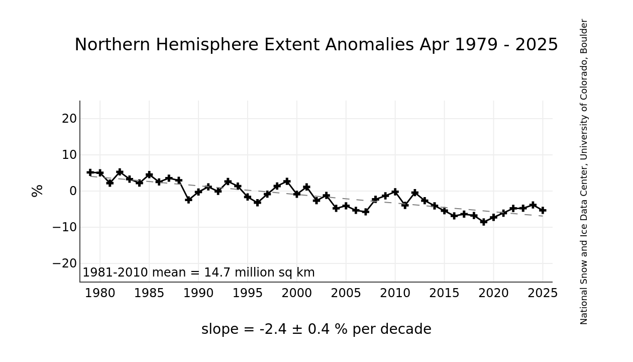
A final observation: The graph below shows the Yearend Arctic Ice Extents for the last 35 years.
Year-end Arctic ice extents (last 5 days of December) show three distinct regimes: 1989-1998, 1998-2010, 2010-2025. The average year-end extent 1989-2010 is 13.4M km2. In the last decade, 2011 was 13.0M km2, and six years later, 2017 was 12.3M km2. 2021 rose back to 13.0 2024 slipped back to 12.2M, and 2025 is back up to 12.4M. So for all the the fluctuations, the net is virually zero, or a loss of one tenth of a Wadham (0.1M) from 2010. Talk of an Arctic ice death spiral is fanciful.
These data show a noisy, highly variable natural phenomenon. Clearly, unpredictable factors are in play, principally water structure and circulation, atmospheric circulation regimes, and also incursions and storms. And in the longer view, today’s extents are not unusual.
The graph shows a reconstruction of September Arctic sea ice extent (the summer minimum) from ~1900 to ~2013, based on work by Alekseev et al. (2016), as presented in Connolly et al. (2017).
It uses red bars for year-to-year values (reconstructed pre-1979, satellite-observed post-1979).
A blue trend line is overlaid.
The annotation points to a low point around the 1930s–1940s and accuses “alarmists” of starting trends from ~1979 (satellite era) while “ignoring” earlier lows.
There was a significant dip in sea ice during the Early Twentieth Century Warming (ETCW, ~1920s–1940s), with extent roughly comparable to (or only slightly higher than) recent lows. This suggests natural variability played a big role, and modern decline isn’t unprecedented.
The method relies on a statistical relationship between summer Arctic surface air temperatures (from weather stations) and satellite-era sea ice extent. They essentially used temperature data as a proxy to “back-calculate” ice extent before direct observations.


You must be logged in to post a comment.